Newly Revised and made more user-friendly!
OCTOBER 2025
A RARE MAP BY BENJAMIN DONN AT AUCTION
Benjamin Donn´s A Map of the County of Devon is quite well known and can be found on this website at entry 44 (12 sheet map) and 45 (the accompanying index map).
However, his map of the Western Circuit of England is less well known and significantly rarer.
This map covers Cornwall, Devon, Dorset, Wilts & Hants and measures 830 x 1340 mm. Dedicated to the Earl of Salisbury (and others) it includes inset maps of Plymouth and Portsmouth harbours and the Scillies. A copy came up for auction recently and the hammer went down at 2000 pounds. It is probably on sale at a London dealer´s for double!!
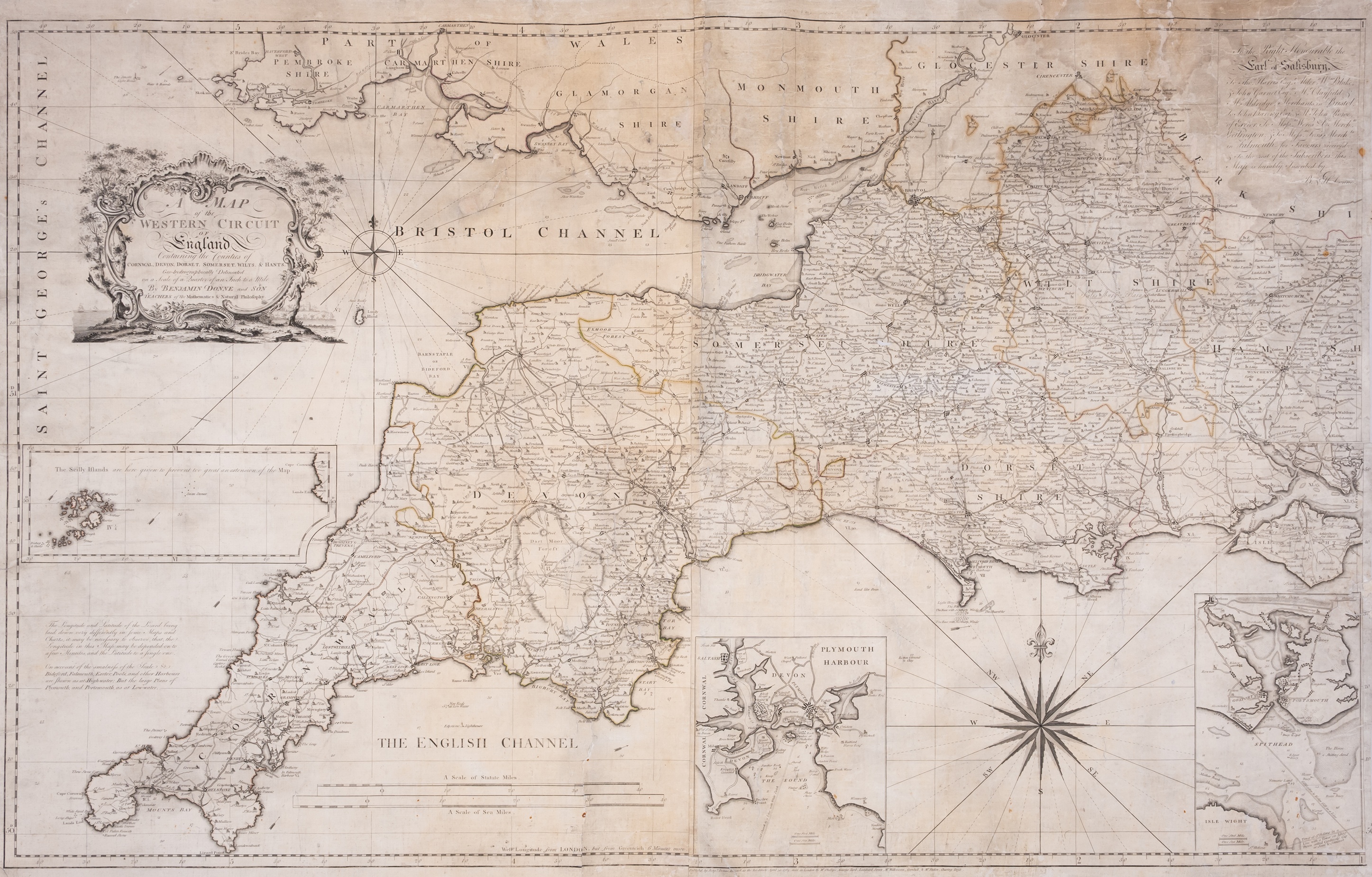
Image copyright Forum Auctions, London. Another copy is held at the British Library (Shelfmark: Maps K.Top.6.66.2.TAB) which can be accessed online).
Contact KitTheMap@aol.com if you wish to contact me directly!
I would really enjoy hearing from other collectors.
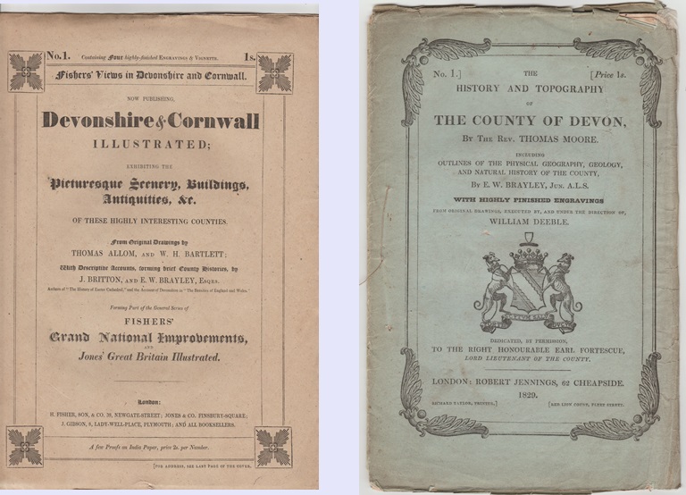
Two works with maps originally published as serial works from 1829 - updated April 2025
Jennings vs. Fisher
Both Thomas Moore with his publisher Jennings and Henry Fisher began a serial publication which included illustrated plates and maps in 1829. While Fisher's work was completed in 1832 (see entry 102), Moore's book would not be complete until 1836 (see entry 115).
I recently acquired two bundles of papers: one is a second set of Fisher´s Devonshire and Cornwall Illustrated (I now have the only two recorded sets); the other is an almost complete set of the quarto set of Jennings´ History of Devonshire (the only set known with 50 numbers or Parts). This has now been completely updated.
The Eyre Brothers - London publishers with an interest in the westcountry
The Eyre Brothers were London publishers who flourished for a brief period in the last quarter of the 19th century with premises first (from 1877) at 10, later from 26 & 27, Paternoster Square, Paternoster Row (until c.1889). Their output was limited to a number of trade and town directories and a few guides to the hotels and typical watering places of England and Wales.
This is the fascinating story of one man - George Pallant Butcher - and his career as a business entrepreneur, first publishing town directories with two others before starting up as the Eyre Brothers. He was the name behind Eyre´s Post Office Directory of Plymouth, issued from 1880 to 1904.
After 1891 he moved to south Devon and lived in South Brent until his death.
The Eyre Brothers Click for access!
2023: The smaller maps published by Robert Morden from 1701
Recently Updated
I have totally rewritten my entry for Robert Morden (22) to include the wide variety of copies of the county extracted from Magna Britannia et Hibernia first issued from 1715. Many collectors have the section covering Devonshire but cannot be sure if they were extracted from a "cut up" bound copy. Most were, in fact, sold as county histories under a variety of titles, or even without title page. The history of these copies is looked at more closely in my blog article.
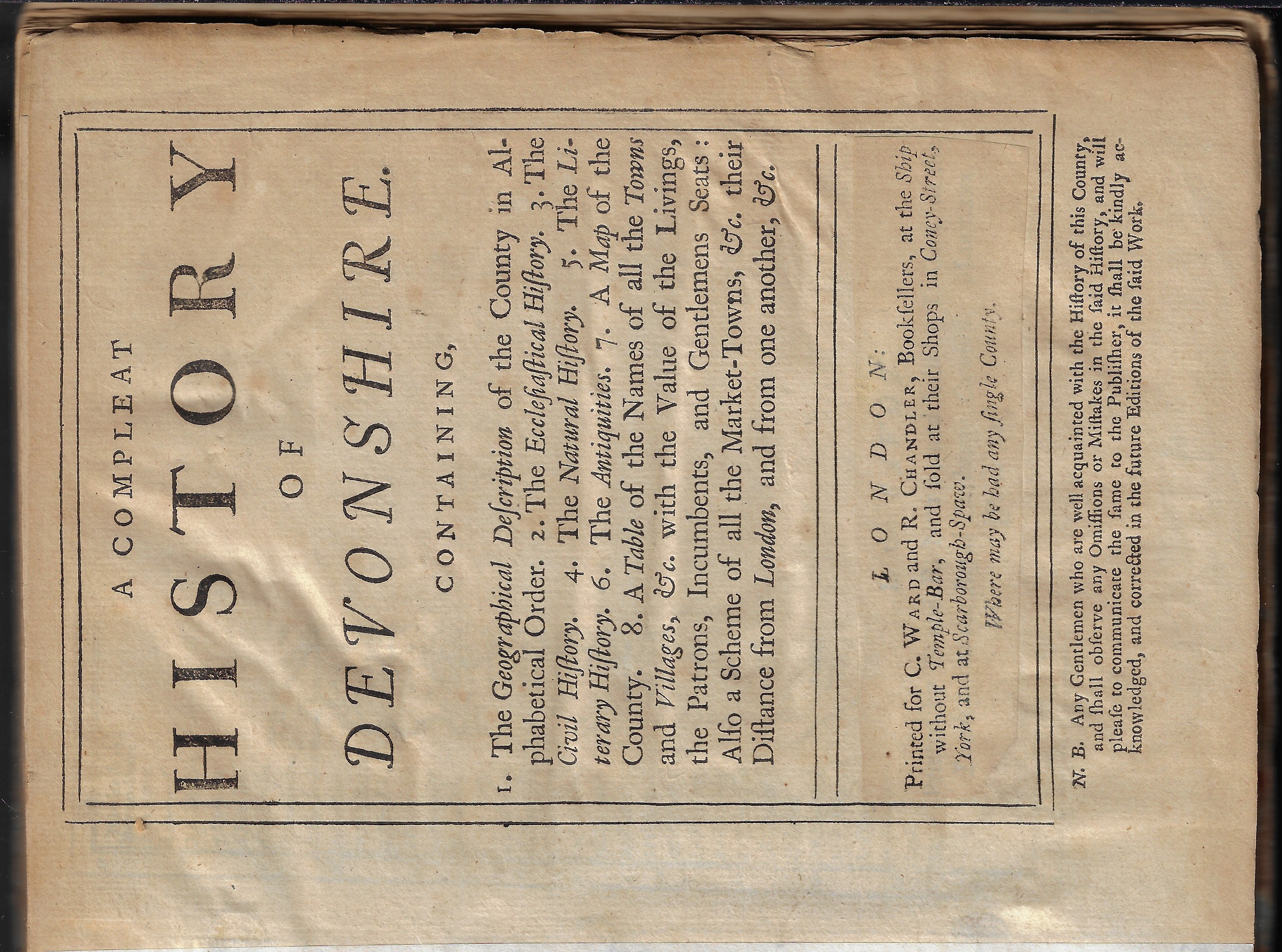
A Compleat History of Devonshire appeared circa 1730. The image is a recently discovered copy of Ward & Chandler´s reissue of 1738-9: in an attempt to sell off old printed stock. Other titles were publshed later until circa 1800. Copies with no title page are possibly slightly earlier. Click here for direct access.
2023: John Bartholomew's Half-Inch map series from 1895
Recently Updated
I donated my collection of John Bartholomew Half-Inch maps to the Devon Heritage Centre in Exeter. This was a popular series of maps and was probably printed in millions of copies as it covered the complete country and was constantly being updated. My blog attempts to give a broad outline of the sorts of things to look for if you have an example and are trying to date it.
Find out more at Bartholomew's Half-Inch maps.
John Cooke- publisher and engraver of Plymouth
NEW UPDATE: I have recently put the finishing touches to my Third Edition of this book and will be posting it shortly. Complete with more images of non-cartographic work by Cooke. In addition more samples of his work have been found.
John Cooke
Rhine strip maps - Leporellos
And now for somthing completely different ...
For those interested in unusual maps, the Rhine leporellos are long folding-out maps. For a long time I had an interesting collection of these and catalogued all the various pre-1900 examples I found. You can find these at
Rhine Panoramas
BlogSpot Articles - Devon Interest
So far, my blogspot has the following cartographic topics
County Maps of Devon - an attempt to list as many printed maps of Devon as I can (pre-1900),
The Printed Maps of Exeter - an updated version of our 2010 book,
an article on Jennings vs. Fisher (two publishing rivals of 1829),
the work of John Cooke, engraver and publisher in Devonport,
an overview of the Half-Inch maps by John Bartholomew 1895-1901,
an article on The Development of the Railways (in Devon) as a guide to dating Victorian maps
an article on the Eyre Brothers who published a number of works with Devon interest,
Tobias Mayer´s Year - an article I wrote for IMCoS
and a catalogue and description of Rhine Leporello Foldout Maps.
Constantly being revised:
Tourist Maps of Devon - My "magnus opus". The on-line version with a complete listing of tourist maps from guides etc. and folding maps to 1901 with details of the people behind them - has now been updated and completed.
Check out:
Kit's Blog Home Page for a full list including my latest research
Website - Maps for Sale
In addition to the websites mentioned above, I also have a site where a number of my maps and guides are listed. If you are interested in purchasing maps, guides, books of reference etc which you see listed in Printed Maps or in Victorian Maps as being in my collection, do not hesitate to contact me. many of them are listed here at Maps for Sale.

 7 showing the whole of the county of
Devon on either one or two sheets. Although this omitted Ordnance
Survey sheets and those atlases designed on a sheet basis, this
meant that we were still able to list 117 different maps along with
their sources and provide information on the people behind
them.
7 showing the whole of the county of
Devon on either one or two sheets. Although this omitted Ordnance
Survey sheets and those atlases designed on a sheet basis, this
meant that we were still able to list 117 different maps along with
their sources and provide information on the people behind
them.